Guinate-Gallo-Máguez

Guinate-Gallo-Máguez

ADDRESSING: Leave a car in Máguez and another at the entrance of Guinate (a few hundred meters to the left). DISTANCE: 4 miles. DIFFICULTY: Low. DURATION: Two hours, two hours. PLEASE NOTE: Wear appropriate clothing and shoes. Water. Some chocolate and pastries. Hat and sunscreen. Do not forget the phone.

As usual the north of Lanzarote, this is a path full of striking contrasts. About 100 meters from the entrance to Guinate, left, find a comfortable path upward about five feet wide. Our back the garrison of the Corona Volcano, omnipresent throughout the day along with other volcanic cones with different features and colors. There is a thick blanket of silence that accompanies the cold clouds and brings the dawn. The elevation is abordabl and with minimum fitness and the conditions of sufficient security for the eyes flit around us.

Cuevita para el descanso de ganaderos en el norte de Lanzarote, Guinate-Gallo-Máguez, senderismo en Lanzarote

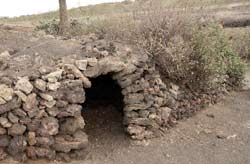
In various sections stumble with gorse, cruets, veroles, tabaibas, traditional crops such as figs and grapes. In this rugged area also emerge as the Toji wildflowers, lavender, lamb’s tail and poppy. Intermittently, our attention little nooks built with natural stone to rest livestock themselves (see photo at right) scattered in the triangle of Guinate, Gallo and Máguez. The rich biodiversity is complemented given the presence of birds such as falcons, quail and doves.

Vistas de La Graciosa, sendero Guinate-Gallo-Máguez, senderismo en Lanzarote

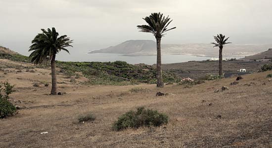
However, postal traffic landscape from this spot the stars of the day. A fifteen minute walk, we stumble across a beautiful image of the island of La Graciosa and Montaña Clara’s profile on the horizon (Chinijo Archipelago, northwest of Lanzarote). The Guinate ravine, with the town at its mouth, dotted with vines and palm trees and whimsical birth Veroles pink flowers make up the rest of the picture.

As the Corona Volcano behind us, the islands of Archipelago Chinijo are a constant in the path. As we move to the southeast, and Máguez Gallo, perceive other very curious Yellow Mountain profiles of La Graciosa, Montaña Clara and Alegranza islet, which share the immense display of Famara cliff. These jewels Atlantic invite to leave the safe path and approach the edge of this cliff. It is just as safe if we take the necessary precautions and the respect they deserve by now and the strong prevailing wind.

Fuentes de Gallo, Guinate-Gallo-Máguez, senderismo en Lanzarote

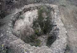
When route, find the sources of Gallo. Waterworks populations Haria, Máguez and mediocrity until the beginning of the desalination and purification in Lanzarote. Today, daisies grow within it, while maintaining its natural stone structure (see photo at right). Towards the coast, continuing progress towards the south, the nautical view postal increases with Famara beach to the south and north islands Chinijo.

Plantaciones de Gallo, Guinate-Gallo-Máguez, senderismo en Lanzarote

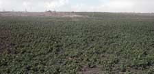
Beyond this space, easily identify the continuation of the path leaving the coast to the right. An airport utility infrastructure is apparent given access to a stretch of road that will lead to Máguez. The road, four to five meters wide, it gets down in a horseshoe shape. Now, with the Corona Volcano in front, the landscape is transformed into a vast wilderness area of various crops in sanded and terraces. Heavy tonali dark ties mountains contrast with the green color splashed the ravine toward the northern town of plantations browns that dominate the area. Again, the rich landscape surprises us when we scrutinize the slender figures Máguez and would make, although geographically separated, seem to have a special tune.


Ver mapa más grande

You might also like

Explore similar topics

Guinate-Gallo-Máguez

CÓMO ABORDARLO: Dejar un coche en Máguez y otro en la entrada de Guinate (a unos cien metros a la izquierda). DISTANCIA: 4 kilómetros aproximadamente. DIFICULTAD: Baja. DURACIÓN: Dos horas- dos horas y media. A TENER EN CUENTA: Llevar ropa y calzado adecuado. Agua. Alguna chocolatina y bollería. Gorra y crema solar. No nos olvidemos del móvil.

Como acostumbra el norte lanzaroteño, es éste un sendero lleno de sorprendentes contrastes. A unos 100 metros de la entrada a Guinate, a la izquierda, encontraremos una cómoda vereda ascendente de unos cinco metros de ancho. Nuestra espalda la guarece el Volcán de la Corona, omnipresente a lo largo de la jornada junto a otros conos volcánicos con diferentes características y tonalidades. Hay un manto de espeso silencio que acompaña a las nubes y el frío que trae el alba. La cota resulta abordable con un mínimo de forma física y se dan las condiciones de suficiente seguridad para revolotear la mirada a nuestro alrededor.

Cuevita para el descanso de ganaderos en el norte de Lanzarote, Guinate-Gallo-Máguez, senderismo en Lanzarote

En distintos tramos tropezaremos con aulagas, vinagreras, veroles, tabaibas, higueras y cultivos tradicionales como la vid. En este accidentado espacio también brotan flores silvestres como el tojio, la lavanda, el rabo de cordero y la amapola. De manera intermitente, llamarán nuestra atención pequeños recovecos construidos con piedra natural propios para el descanso ganadero (ver foto a la derecha) desperdigados en el triángulo de Guinate, Gallo y Máguez. La rica biodiversidad se ve complementada con la presencia de aves como los cernícalos, las codornices y las tórtolas.

Vistas de La Graciosa, sendero Guinate-Gallo-Máguez, senderismo en Lanzarote

Sin embargo, las postales paisajísticas procedentes del tránsito por este paraje protagonizan el día. A los quince minutos de camino, tropezaremos con una bella imagen de la isla de La Graciosa y el perfil de Montaña Clara en el horizonte (islas del Archipiélago Chinijo, al noroeste de Lanzarote). El barranco de Guinate, con el pueblo en su desembocadura, salpicado de parras y palmeras y el caprichoso nacimiento de las flores rosadas de veroles conforman el resto del cuadro.

Como el Volcán de la Corona a nuestra espalda, las islas de Archipiélago Chinijo son una constante en el sendero. Según avancemos en dirección sureste, a Gallo y Máguez, percibiremos otros curiosísimos perfiles de Montaña Amarilla de La Graciosa, Montaña Clara y el islote de Alegranza, que comparten visor con el inmenso risco de Famara. Estas joyas atlánticas invitan a abandonar el camino seguro y acercarse al límite de este risco. Es igual de seguro siempre que tomemos las debidas precauciones y el respeto que merecen estas alturas y el fuerte viento dominante.

Fuentes de Gallo, Guinate-Gallo-Máguez, senderismo en Lanzarote

A la hora de ruta, encontraremos las fuentes de Gallo. Abastecedoras de agua de las poblaciones de Haría, Máguez y medianías hasta la irrupción de las desaladoras y potabilizadoras en Lanzarote. Hoy, crecen las margaritas en su seno, aunque mantiene su estructura de piedra natural (ver foto a la derecha). Hacia la costa, seguimos avanzando hacia el sur, la vista náutica se incrementa con la postal de playa de Famara al sur y las islas de Chinijo al norte.

Plantaciones de Gallo, Guinate-Gallo-Máguez, senderismo en Lanzarote

Superado este espacio, identificaremos con facilidad la continuación del sendero dejando la costa a la derecha. Una infraestructura de aparente utilidad aeroportuaria es la figura de acceso a un tramo de carretera que nos conducirá a Máguez. El camino, de cuatro a cinco metros de anchura, se torna descendente en forma de herradura. Ahora, con el Volcán de la Corona de frente, el paisaje se transforma en una basta extensión agreste de diversos cultivos en enarenados y bancales. Las fuertes tonalidades oscuras de las montañas contrastan con el color verde que salpica el barranco en dirección al pueblo norteño de las plantaciones de papas y cebollas que predominan en la zona. Nuevamente, la riqueza paisajística nos sorprende cuando escrutamos las esbeltas figuras de Máguez y Haría que, aunque separadas geográficamente, parecen mantener una especial sintonía.


Ver mapa más grande

Para después del pateo: Dos horas o dos horas y media lleva el sendero. En el cercano pueblo de Haría hay variada oferta de restauración. Si vamos con niños, podemos complementar la excursión con la visita a Las Pardelas Park de Órzola. Los Centros Turísticos del Mirador del Río, Cueva de los Verdes o Jameos del Agua constituyen otra alternativa. En la costa de Arrieta y Punta Mujeres se concentran algunas de las mejores ofertas de pescado fresco en la isla. Amanecer es una de ellas.

You might also like

Explore similar topics

Similar Articles:

Femés-Papagayo

To the heart of the Natural Monument of Los Ajaches. This is a path that will allow us to cross one of the natural attractions of southern Lanzarote. Can not be compared with its neighbors and the Timanfaya Geria, but the route, visually monotonous in almost all the way, trapped by his strange charm. Although not difficult nor extremely hard the road, no recommendations addressed to children under 14 years.

Teguise – Famara

At times we will only have eyes for the <strong>immense Famara cliff</strong>. But our eyes, inevitably get caught by the beauty of the islands of <strong>La Graciosa</strong>, <strong>Alegranza</strong> and <strong>Montaña Clara</strong>. Back on Lanzarote, the <strong>extension of the natural volcanic sand called <em>jable</em></strong> seems endless from above and it gets less dry and yellowish as our gaze moves towards Mozaga.

Haría – El Bosquecillo

The valley of the thousand palm trees of Haría is one of the most spectacular pieces of the varied landscape of Lanzarote.

Femés-Playa Quemada

In the direction of Playa Quemada, one of the most spectacular beach on the island. From the first moment we perceive the immense valley of Femés to cross during the day. In general, the paths to walk are tight, corresponding to very traditional herds of goats in the area. Accordingly, in a first stage, we must walk carefully along the banks of the trail and very zigzaceantes soil slopes, uneven and poor care.