Haría – El Bosquecillo
Text: Leisure Lanzarote. Photography: Dani Stein.
WHERE TO START: Park a car in El Bosquecillo and another in the village of Haría. DISTANCE: 4.4 miles [7 kilometers]. DIFFICULTY: Medium-low. DURATION: An hour and a half. WHAT TO BRING: Wear appropriate clothing and shoes. Bring water, some chocolate or snacks, a hat and sun screen. Do not forget your cell phone. AFTER THE WALK: Barbecue in El Bosquecillo, lunch in Haría or Arrieta. Take a swim in Arrieta. The Guinate Tropical Park, ideal for children. Have a coffee in Mirador del Río.
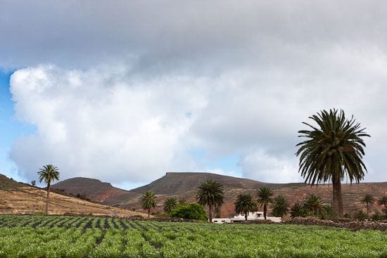
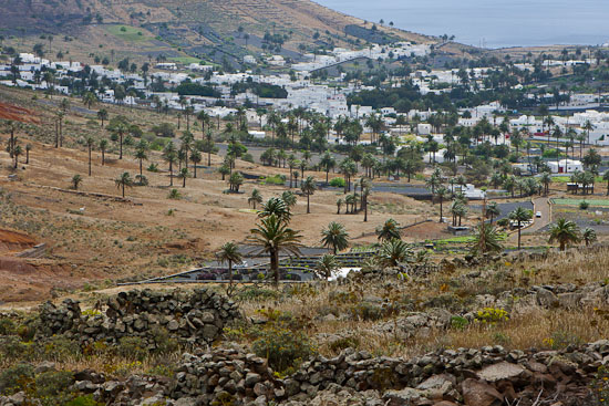
This hiking route in the north of Lanzarote starts right in the heart of the valley of a thousand palm trees of Haría. We can find the starting point placing ourselves in front of the northern soccer institute and field, where, approximately only 200 yards to the right, leaving behind the village of Haría (to the northwest), we will find a dirt road. This trail, with a slight climbing slope, will take us in a zigzag to El Bosquecillo, one of the few places dedicated to outdoor family leisure in Lanzarote. The outskirts of the town of Haría are characterized by the presence of vestiges of the traditional agricultural past. Miles and miles of cultivated land, patiently protected with natural stone merge with the aridity of the mountain landscape and the slim figure of the Haría palms.
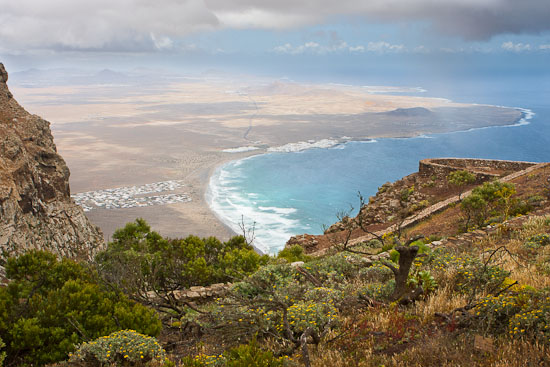
The first compulsory stop is after a half-hour hike. It is more than just a rest, it’s for our visual delight. We shall identify this place very easily because it is at the limit with the northwest coast of Lanzarote, on a wide natural stone plateau. The landscape is spectacular and the sea is the main character. The view of Famara, at about 1,600 feet [500 meters] up, looks like a gigantic postcard . This cliff looks majestic and menacing at the same time, with only a few birds daring to fly over it. A deathly silence accompanies the contemplation of Famara beach, so small seen from up here, with its seemingly tiny waves breaking imperceptibly against the shore. You turn your head back to the way you came from and you see palm trees, fig trees, grapevines and the playful composition of the village of Haría; you turn your gaze back to the sea and you’re flooded by the deep ocean blue and the majesty of the cliff of Famara.
After regaining your energy, you continue along the trail towards Malpaso valley, which joins the peak of Las Nieves, the highest point of Lanzarote, with Haría. The trail takes us to the slopes of Malpaso, where man’s hand remains intact, in its endeavor to guarantee his food, based on corn, potatoes, tomatoes, sweet potatoes, figs and grapes. The farther you get from Haría, the more it surprises you to see how difficult it must have been to be a farmer.
At the one-hour mark of the hike we find the second resting place. It will be easy to spot the location. At the beginning of the Malpaso valley, there are some twenty pine trees, the tops of which offer an immense shade that you will surely enjoy. This is a good time to recover your breath and have some water before the last half hour of hiking, while you gaze at the whole valley, with Haría as the background of a spectacular picture.
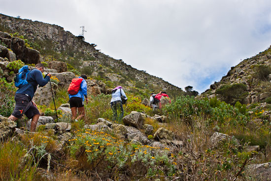
This last third part of the trail is the most complicated because of the orographic difficulties. The trail becomes extremely narrow, surrounded by stones and small bushes, and the climbing angle of the hike increases too. The effort is greater, but not excessive, if we are in a somewhat good physical shape. Pay attention to possible encounters on your way, because it is quite likely that you will see some rabbits, restless by nature, and the traditional and enemy presence of the local hunters. Once we surmount this climb, we will find the trail towards El Bosquecillo a few hundred yards farther on. The barbecue grills are duly equipped for the traditional pinchos de carne (meat skewers), chuletas (ribs) or solomillos (tenderloins). There is a large playground in which the equipment is not exactly the best.

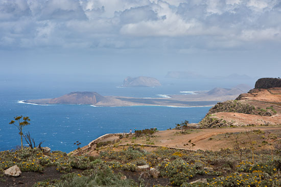
At the viewpoint of El Bosquecillo we will be able to appreciate again the different views with the option of looking at Famara or even a small but significant point on the island of La Graciosa (an island of the Chinijo Archipielago, to the north of Lanzarote), Montaña Amarilla. The reader must not get confused by the terminology and expect to find thousands of acres of pine trees, Indian laurel or Canarian palm trees. Unfortunately, El Bosquecillo is made up of a few small trees, about a hundred, many of them burnt, others in bad shape, but in spite of this they are still thriving. The local slyness has renamed the place El Peladillo (The Baldie), because of the lack of a varied tree vegetation. Either way, this is a good place for sports, table games, contemplation, reading, and for the more lively a nice fiesta with Spanish small string instruments called timples and guitars.
Note: Leisure Lanzarote grateful for the photographic work of Daniel Stein illustrating this post informative. His photos.