Camino de los Gracioseros

Camino de los Gracioseros

Para realizar el antiguo Camino de Los Gracioseros que te llevará a la preciosa Playa del Risco, debes acceder en coche hasta las cercanías del Mirador de Yé.

camino los gracioseros sendero
El exigente Camino de los Gracioseros depara espectaculares vistas del Archipiélago Chinijo

A la salida del pueblo de Yé, en dirección a Guinate, encontrarás un cartel que anuncia un desvío hacia el Mirador del Río.

Unos 300 metros después de haber tomado esta salida podrás ver a tu derecha el hotel rural Finca La Corona.

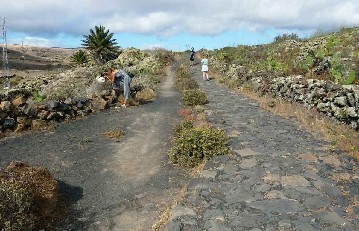
Trás visualizar este conjunto de villas rurales, a tu izquierda verás un amplio camino empedrado.

acceso al aparcamiento mirador de ye

Accede al mismo con tu vehículo. Normalmente hay espacio para estacionar.

aparcamiento mirador de ye

Una vez estacionado el coche, sigue la vereda de piedra natural.

Camino de acceso al mirador de ye

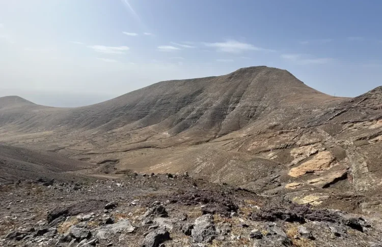
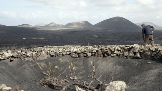
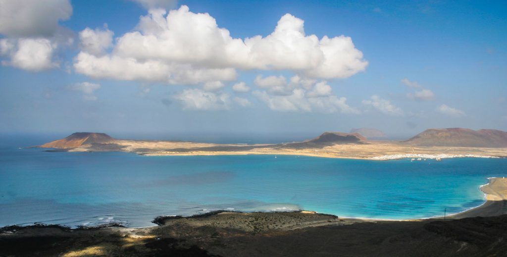
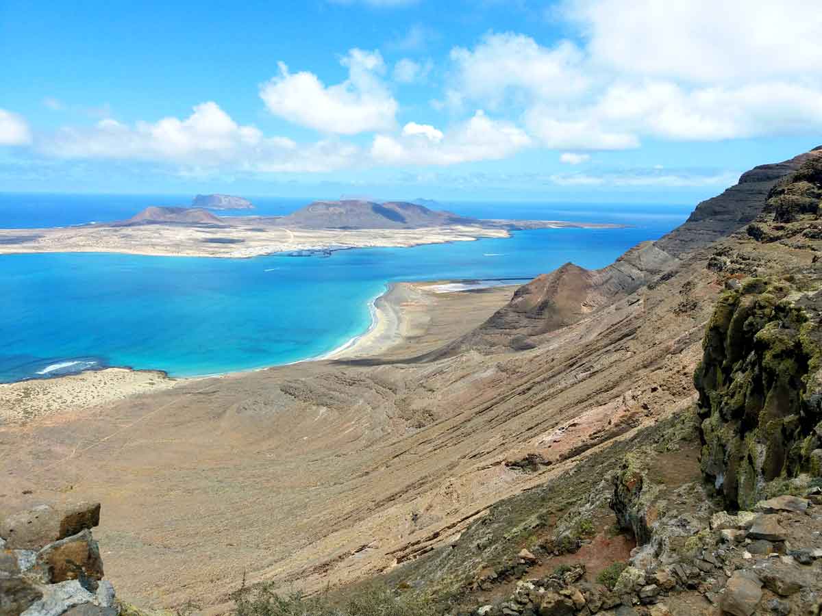
En menos de 5 minutos llegarás hasta un coqueto mirador desde donde verás la espectacular estampa del Archipiélago Chinijo.

mirador de ye

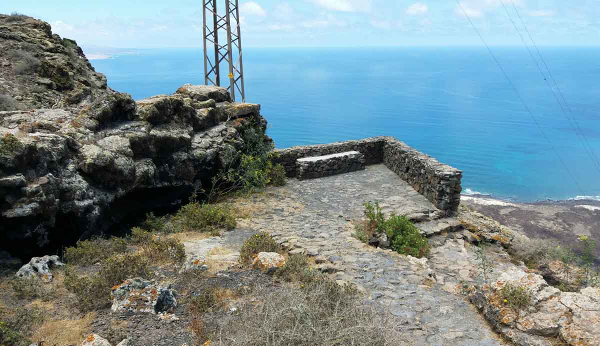
Desde este mirador, si miras hacia abajo, se percibe con nitidez el camino en zig zag que nos situará en la Playa del Risco.

sendero de bajada en zig zag

En días despejados se logra contemplar La Graciosa, Montaña Clara, Roque del Oeste y Alegranza.

Junto a la Playa del Risco, un poco más a la derecha, se observan las Salinas del Río.

vistas desde el mirador de ye

Un sendero exigente

Este sendero en sí es sencillo, pero se hace bastante exigente a nivel físico por la fuerte pendiente.

En poco tiempo y en muy poca distancia pasarás de los 600 a los 0 metros del nivel del mar.

Además, el exceso de piedra obliga a estar muy concentrados sobre el firme que pisamos.

Por este motivo no lo recomendamos para realizar con niños.

Lo suyo sería aprovechar los extremos de cada zigzagueo para contemplar la maravillosa vista, pero también para volver la mirada al camino transitado y dejarnos llevar por la fortaleza visual del risco de Famara.

Por ello, no está de más hacer un buen calentamiento físico previo, con especial atención a los ejercicios de piernas.

Es muy importante llevar ropa y calzado cómodo y adecuado.

Así como abundante agua, algo de alimento que aporte energía, gorra y crema solar.

Además de por las espectaculares fotos, será conveniente que no olvides llevar tu móvil por si surge algún inconveniente.

Llegando al objetivo

A los 45 minutos aproximados de caminata, la fuerte pendiente se suaviza a la vez que el sendero gana en anchura y comodidad.

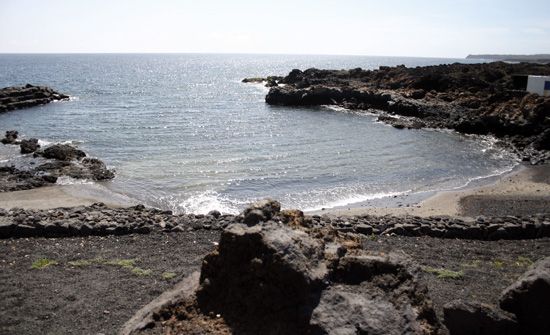
Estamos a los pies de la Playa del risco, que se muestra muy apetecible por sus tranquilas aguas y la calidad de su arena.

La estancia en la playa resulta aprovechable para visitar las Salinas del Río, las primeras de las que se tiene constancia en Canarias.

Actualmente están en desuso, pero mantienen su particular estructura que unido a su enclave le confiere un encanto particular.

La hora del duro ascenso

La vuelta al punto de inicio se realiza por el mismo camino.

Normalmente se emplea algo más de tiempo en subirlo que en bajarlo, aunque dependerá de tu forma física y mental.

Físicamente resulta exigente. Recomendamos que se aborde sin prisa alguna, regulando bien la respiración y tomando las paradas que sean convenientes para retomar fuerzas y oxígeno.

Alcanzar el mirador de Yé se hace muy agradable. Es un buen sitio éste para, nuevamente, hacer unos buenos ejercicios de estiramientos.

Sus piernas se lo agradecerán con el paso de las horas.

Un sendero con mucha historia

La ruta tuvo mucha historia de intercambio social y comercial entre La Graciosa y Haría.

En los restaurantes de Caleta del Sebo, en concreto en Girasol, cuelgan algunas fotografías que reflejan a las mujeres gracioseras transportando cestos cargados de pescado y sal.

Desde el punto de vista de la vegetación, este enclave constituye uno de los puntos más completos de la isla.

Según señala Nieves Morales, directora de la Casa de los Volcanes de Lanzarote, la zona «alberga los distintos tipos de comunidades vegetales existentes en Lanzarote, de ellas 19 son endémicos de Lanzarote e islotes y 14 exclusivos del Risco de Famara».

En el camino, pues, se podrán observar distintas especies como el bobo, aulagas, veroles, tuneras, vinagreras o tojio.

El silencio abrumador del espacio se rompe por los chirridos de las abundantes colonias de aves como la pardela cenicienta, el águila pescadora o guincho, el halcón peregrino y los cernícalos.

También resulta común ver perdices, guirres, tórtolas y palomas, entre otras especies.

En esta zona abundan los conejos, por lo que, en ocasiones, podrás encontrarte con cazadores, sus hurones y perros olfateando el espacio en busca de una presa.

Mapa del sendero Camino de Los Gracioseros

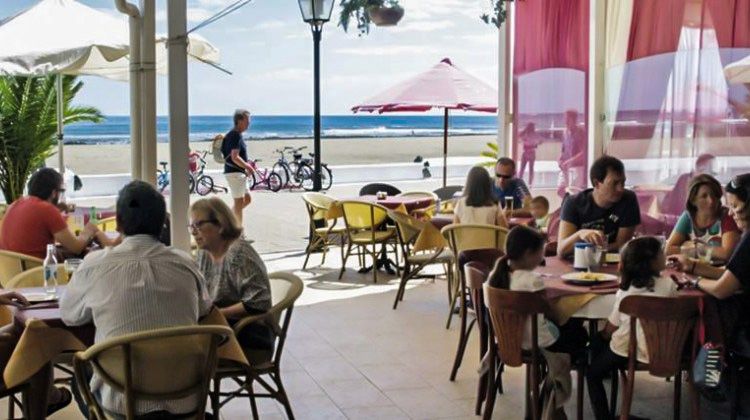
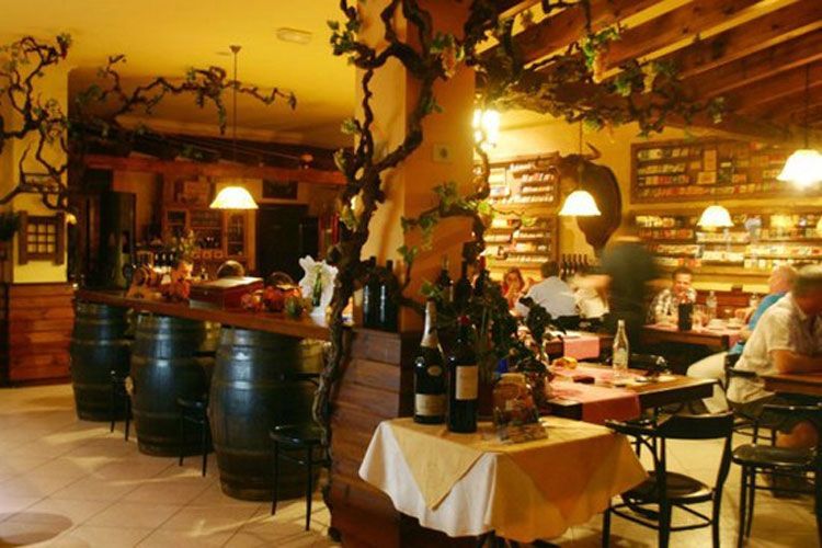
Para antes y después: De manera más sosegada podemos tomar un refrigerio con vistas al río y el Archipiélago Chinijo desde el Mirador del Río. Desde este punto se perciben las salinas y la playa del risco. Si concluimos el ascenso entre las 13:00-13:30 horas, el pescado de Amanecer de Arrieta es una muy buena opción para recuperar fuerzas.

Nota: Ocio Lanzarote agradece el trabajo fotográfico de Dani Stein que ilustra esta entrada informativa. Sus fotos.

También te puede gustar

Explora temas similares

Camino de los gracioceros

Text: Leisure Lanzarote. Photography: Dani Stein.

WHERE TO START: Park your car on a cobblestone-paved road which you take at the exit of the village of Yé towards Guinate. This is not an adequate trail for children. DIFFICULTY: Medium-high. DURATION: The descent is made in approximately 45 minutes to an hour. The ascent will take between an hour and a quarter and an hour and a half. WHAT TO BRING: The strong grade of the descending and climbing slope (you descend from 2.000 to 0 feet [600 to 0 meters] in only an hour makes a good warm-up advisable, with special attention to flexibility exercises of the lower limbs. Wear appropriate clothing and shoes. Bring water (in this case, lots of water), some chocolate or snacks, a hat and sun screen. Do not forget your cell phone..

Leaving the village of Yé towards Guinate you will find a sign that announces a side road to Mirador del Río. Approximately 300 yards after taking this road you will see a building that is rather different from the urban constructions of this area in the north of Lanzarote. It is the rural hotel Finca La Corona. At a short distance, to the left, there is a cobblestone-paved road where we can park our vehicle. As we recommend in the box on the left, this trail is quite demanding physically because of the strong downward and upward climb that we will tackle. In a short time, and in a very short distance, we will go from 2.000 to 0 feet [600 to 0 meters] above sea level. Because of this, it’s a good idea to do some good warm-up exercises on the cobblestoned parking area, paying special attention to flexibility exercises of the lower limbs.

Following the natural stone path, we find a nice viewpoint that places us in front of the always attractive sight of the Chinijo Archipelago. On clear days, you can see La Graciosa, Montaña Clara, Roque del Oeste and Alegranza islands. From here it is possible to see clearly the zigzagging trail that will take us to the Del Risco beach and the Del Río salt mines (the oldest on the Canaries, and from which there are references in the first chronicles of the conquest).

caminolosgracioseros

The route had a lot of social and commercial trade between La Graciosa and Haría. In the restaurants of Caleta del Sebo, especially at Girasol, there are some photographs that show women from La Graciosa carrying baskets full of fish and salt. Today, at the beginning of October 2008, while descending we come across a woman in her 70s who climbs with enviable agility. She is carrying a home-made speargun, wearing flip-flops and a traditional hat. She does not descend and climb in vain. She has a backpack well loaded with octopus on her back. We ask her: «How was it?» «There are some octopus left…I did not go in vain», she answers. I did not go in vain. For her going hiking to look at nature or just to work out would be unthinkable.

The trail is not difficult, but all the rocks force you to concentrate carefully on where you step. It’s best to take advantage of each turn in the zigzagging to gaze at the marvelous view, but also to look back at the road already covered and let ourselves be taken by the visual power of the cliff of Famara. From a vegetation point of view, this enclave is one of the most complete on the island. As she says in this complete work, Nieves Morales, director of the Casa de los Volcanes de Lanzarote, the area «houses all the different types of vegetable species that exist in Lanzarote, 19 of them are endemic to Lanzarote, and of these, 14 are exclusive to the Cliff of Famara.» Therefore, on the trail you will be able to see different species like bobo trees, gorse bushes or aulagas, a local kind of Euphorbia called veroles, prickly pear cacti or tuneras, sorrels or vinagreras or a type of daisy called tojio.

caminolosgracioseros

The overwhelming silence of the place is broken by the cries of the abundant bird colonies like the gull-like pardelas, fishing eagles or guinchos, peregrine falcons and kestrels. It is also common to hear partridges, vultures, turtledoves and pigeons, among other species. This is an area where rabbits abound. Hunters can also be seen on the trail, along with their ferrets and dogs sniffing the area looking for some prey.

After about 45 minutes hiking, the steep slope levels out and the trail becomes wider and more comfortable. We are at the foot of the cliff, by the beach, which is very attractive because of its tranquil waters and the quality of its sand. In front of the coast the «river» that separates La Graciosa from Lanzarote, Caleta del Sebo and Montaña Amarilla gives a special character to this secluded place. It’s a good idea to take some time to regain strength in our legs with some soothing stretching exercises. Soothing, yes, but also preventive, because after the paddles, playing soccer, the refreshing swim and the snacks we still have to climb back.

caminolosgracioseros

The stay at the beach is very convenient for a visit to the Del Río salt mines. As we said above, they are the first salt mines there is record of on the Canaries, according to the first chronicles of the conquest of the Americas in the 15th century (more details). Nowadays they are not in use, but they maintain their particular structure, which along with their location, gives them a particular charm.

The return to the starting point is by the same route as the downward hike. It is physically demanding. We recommend tackling it in no hurry, regulating breathing well and making any stops that’s needed to regain your strength and breath. It is very pleasant when you reach the viewpoint of Yé. Once more, this is a good place to do some good stretching exercises. Your legs will thank you in a few hours.

Note: Leisure Lanzarote grateful for the photographic work of Daniel Stein illustrating this post informative. His photos.


See the map in a larger size

What to do before and after: As a more relaxed alternative we can have a refreshment with the views of the river and the Chinijo Archipelago from the Mirador del Río. It is possible to see the salt mines and the cliff beach from this point. If you finish your climb around 1 or 1:30 p.m., the fish at Amanecer of Arrieta is a very good option to regain your strength. Something lighter and cheaper, a few miles farther south, in Guatiza…some good tapas.

También te puede gustar

Explora temas similares

Artículos similares:

Ruta en bicicleta: Arrecife-Puerto Calero-Arrecife

A primera vista podríamos pensar que la ruta es sencilla: salimos por la Avenida, pasando por Playa Honda y llegamos a Matagorda… Nada más lejos de la realidad. Esta ruta que hoy proponemos es un poco más enrevesada.

Ruta en bicicleta: Arrecife-Costa Teguise-Arrieta-Los Valles

Una vez hemos llegado a Arrieta, empieza lo bueno. Justo antes del pueblo, hay un cartel que señala “Tabayesco 1”. Tomamos esa carretera y empieza una subida resguardada del viento, pero larga como ella sola. Es una ruta preciosa, llena de revueltas, que se debe tomar con calma. Usaremos casi siempre plato mediano e incluso alguno tirará del plato chico, aunque no es necesario.

Ruta en bicicleta: Monumento al Campesino-La Santa

El centro de Lanzarote es especialmente recomendable, en días de poco viento, para las rutas cicloturistas de cualquier nivel. Hay múltiples opciones y direcciones que tomar, pero para este itinerario en particular se ha tomado la posibilidad de aprovechar unas bajadas y subidas sencillas.

Femés-Papagayo

Una dura ruta que atraviesa el Monumento Natural de Los Ajaches. El camino recorrido durante las cuatro horas aproximadas de pateo resulta muy monótono, pero en él se obtienen, desde una privilegiada posición, unas magníficas vistas de las bellezas del sur de Lanzarote como las Salinas de Janubio, Playa Blanca con Corralejo e Isla de Lobos al fondo y entre otros puntos de interés algunos recónditos acantilados y calas del sureste de la isla. Tras el intenso ejercicio, nada mejor que las cristalinas aguas de Papagayo para reponer fuerzas.