Haría – El Bosquecillo

Haría – El Bosquecillo

Text: Leisure Lanzarote. Photography: Dani Stein.

WHERE TO START: Park a car in El Bosquecillo and another in the village of Haría. DISTANCE: 4.4 miles [7 kilometers]. DIFFICULTY: Medium-low. DURATION: An hour and a half. WHAT TO BRING: Wear appropriate clothing and shoes. Bring water, some chocolate or snacks, a hat and sun screen. Do not forget your cell phone. AFTER THE WALK: Barbecue in El Bosquecillo, lunch in Haría or Arrieta. Take a swim in Arrieta. The Guinate Tropical Park, ideal for children. Have a coffee in Mirador del Río.

This hiking route in the north of Lanzarote starts right in the heart of the valley of a thousand palm trees of Haría. We can find the starting point placing ourselves in front of the northern soccer institute and field, where, approximately only 200 yards to the right, leaving behind the village of Haría (to the northwest), we will find a dirt road. This trail, with a slight climbing slope, will take us in a zigzag to El Bosquecillo, one of the few places dedicated to outdoor family leisure in Lanzarote. The outskirts of the town of Haría are characterized by the presence of vestiges of the traditional agricultural past. Miles and miles of cultivated land, patiently protected with natural stone merge with the aridity of the mountain landscape and the slim figure of the Haría palms.

Vistas de Haría desde El Bosquecillo, senderismo en Lanzarote

The first compulsory stop is after a half-hour hike. It is more than just a rest, it’s for our visual delight. We shall identify this place very easily because it is at the limit with the northwest coast of Lanzarote, on a wide natural stone plateau. The landscape is spectacular and the sea is the main character. The view of Famara, at about 1,600 feet [500 meters] up, looks like a gigantic postcard . This cliff looks majestic and menacing at the same time, with only a few birds daring to fly over it. A deathly silence accompanies the contemplation of Famara beach, so small seen from up here, with its seemingly tiny waves breaking imperceptibly against the shore. You turn your head back to the way you came from and you see palm trees, fig trees, grapevines and the playful composition of the village of Haría; you turn your gaze back to the sea and you’re flooded by the deep ocean blue and the majesty of the cliff of Famara.

Vistas de Haría desde El Bosquecillo, senderismo en Lanzarote

After regaining your energy, you continue along the trail towards Malpaso valley, which joins the peak of Las Nieves, the highest point of Lanzarote, with Haría. The trail takes us to the slopes of Malpaso, where man’s hand remains intact, in its endeavor to guarantee his food, based on corn, potatoes, tomatoes, sweet potatoes, figs and grapes. The farther you get from Haría, the more it surprises you to see how difficult it must have been to be a farmer.

Vistas de Haría desde El Bosquecillo, senderismo en Lanzarote

At the one-hour mark of the hike we find the second resting place. It will be easy to spot the location. At the beginning of the Malpaso valley, there are some twenty pine trees, the tops of which offer an immense shade that you will surely enjoy. This is a good time to recover your breath and have some water before the last half hour of hiking, while you gaze at the whole valley, with Haría as the background of a spectacular picture.

Vistas de Haría desde El Bosquecillo, senderismo en Lanzarote

This last third part of the trail is the most complicated because of the orographic difficulties. The trail becomes extremely narrow, surrounded by stones and small bushes, and the climbing angle of the hike increases too. The effort is greater, but not excessive, if we are in a somewhat good physical shape. Pay attention to possible encounters on your way, because it is quite likely that you will see some rabbits, restless by nature, and the traditional and enemy presence of the local hunters. Once we surmount this climb, we will find the trail towards El Bosquecillo a few hundred yards farther on. The barbecue grills are duly equipped for the traditional pinchos de carne (meat skewers), chuletas (ribs) or solomillos (tenderloins). There is a large playground in which the equipment is not exactly the best.

Vistas de Haría desde El Bosquecillo, senderismo en Lanzarote

At the viewpoint of El Bosquecillo we will be able to appreciate again the different views with the option of looking at Famara or even a small but significant point on the island of La Graciosa (an island of the Chinijo Archipielago, to the north of Lanzarote), Montaña Amarilla. The reader must not get confused by the terminology and expect to find thousands of acres of pine trees, Indian laurel or Canarian palm trees. Unfortunately, El Bosquecillo is made up of a few small trees, about a hundred, many of them burnt, others in bad shape, but in spite of this they are still thriving. The local slyness has renamed the place El Peladillo (The Baldie), because of the lack of a varied tree vegetation. Either way, this is a good place for sports, table games, contemplation, reading, and for the more lively a nice fiesta with Spanish small string instruments called timples and guitars.

Vistas de Haría desde El Bosquecillo, senderismo en Lanzarote

Note: Leisure Lanzarote grateful for the photographic work of Daniel Stein illustrating this post informative. His photos.


See map at a larger scale

You might also like

Explore similar topics

Haría-El bosquecillo

Texto: Ocio Lanzarote. Fotografía: Dani Stein.

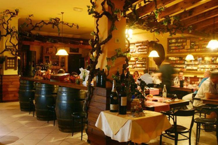
CÓMO ABORDARLO: Dejar un vehículo en El Bosquecillo y otro en el casco urbano de Haría. DISTANCIA: 7 kilómetros. DIFICULTAD: Media-baja. DURACIÓN: Hora y media. A TENER EN CUENTA: Llevar ropa y calzado adecuado. Agua. Alguna chocolatina y bollería. Gorra y crema solar. No nos olvidemos del móvil. PARA DESPUÉS DEL PATEO: Asadero en El Bosquecillo, almorzar en Haría o Arrieta. Darse un chapuzón en Arrieta. Ideal para niños el Parque Tropical Guinate. Tomar un café en Mirador del Río

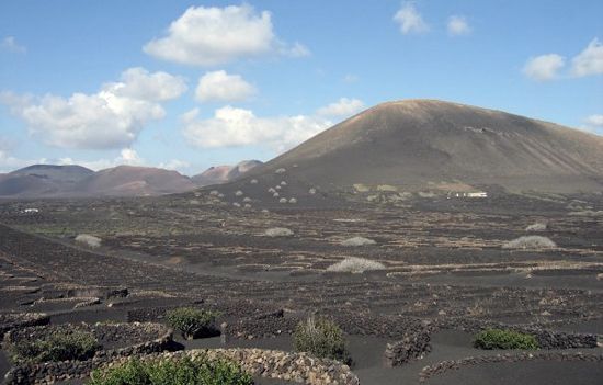
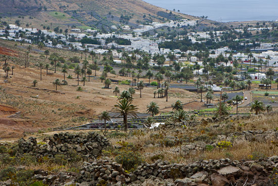
En pleno corazón del valle de las mil palmeras de Haría parte esta ruta de senderismo en el norte de Lanzarote. El punto de inicio lo podremos encontrar situándonos a la altura del instituto y campo de fútbol norteño, donde a unos escasos 200 metros aproximadamente, a la derecha, dejando atrás el casco histórico de Haría (hacia el noroeste), hallaremos un camino de tierra. Esta vereda, ligeramente en pendiente ascendente, nos conducirá zigzagueando a las faldas de El Bosquecillo, uno de los pocos espacios pensados para el ocio familiar al aire libre en Lanzarote. La salida del pueblo de Haría se caracteriza por la presencia de los vestigios del pasado agrícola tradicional.

Vistas de Haría desde El Bosquecillo, senderismo en Lanzarote

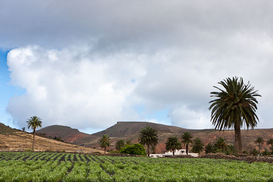
Kilómetros y kilómetros de rincones de cultivo, pacientemente asocados con piedra natural, que se entremezclan con la aridez del paisaje montañoso y la esbelta figura de la palmera hariana. A la media hora de caminata está la primera parada obligatoria. Más que de descanso, que también, de deleite visual. Identificaremos este punto con suma sencillez ya que se encuentra en el límite con la costa noroeste de Lanzarote, en una amplia sentada de piedra natural.

Vistas de Haría desde El Bosquecillo, senderismo en Lanzarote

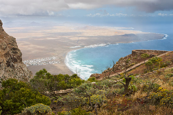
El contrapunto paisajístico, con el mar como principal protagonista, resulta espectacular. La visión de Famara, a unos 500 metros de altura, expone al asistente una gigantesca postal. El risco de esta localidad se muestra imponente y amenazador a la vez, donde sólo unas atrevidas aves se atreven a sobrevolarlo. Un silencio sepulcral acompaña la contemplación de la playa de Famara, tan pequeña desde las alturas, con sus, parecen, diminutas olas rompiendo imperceptiblemente en la costa. Vuelves la cabeza al camino recorrido y encuentras palmeras, higueras, parras y la juguetona composición del pueblo de Haría; retornas la vista hacia la mar y te inunda el azul marítimo y la majestuosidad del risco de Famara.

Vistas de Haría desde El Bosquecillo, senderismo en Lanzarote

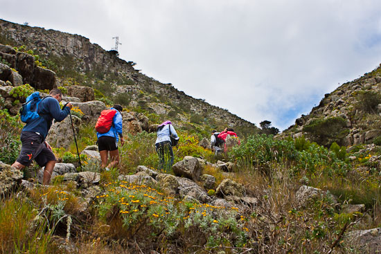
Cargadas las pilas, se continúa por el sendero de tierra en dirección al valle de Malpaso, que une el risco de Las Nieves, el punto más alto de Lanzarote, con Haría. El camino nos lleva a las faldas de Malpaso, donde la mano del hombre permanece intacta, en su afán de garantizarse el alimento a base de millo, papas, tomates, batatas, higos y uvas. Cuanto más lejos Haría, más sorpresas te llevas al comprobar la extrema dureza que suponía la dedicación al campo.

Vistas de Haría desde El Bosquecillo, senderismo en Lanzarote

A la hora de camino encontramos el segundo punto de descanso. El senderista lo identificará a buen seguro. En el inicio del Valle de Malpaso, una veintena de pinos cuyas copas ofrecen una sombra inmensa que se agradece. Buen momento por lo tanto para recuperar el aliento y tomar agua con la vista puesta en la última media hora de pateo, al tiempo que se vislumbra todo el valle, con Haría como fondo de una espectacular fotografía.

Vistas de Haría desde El Bosquecillo, senderismo en Lanzarote

Este último tercio de sendero resulta el más complicado debido a las dificultades orográficas. Se estrecha a su mínima expresión el camino, rodeado de piedra y pequeños arbustos, y se incrementa también el desnivel ascendente de la caminata. El esfuerzo será mayor, pero salvable, si estamos en una mínima forma física. Presten atención a posibles invitados en su camino, porque es bastante posible que atisben a algún conejillo, inquieto por su naturaleza y por la tradicional y enemiga presencia de los cazadores locales.

Superado este desnivel, hallaremos el camino en dirección a El Bosquecillo a unos pocos cientos de metros. Las barbacoas están debidamente equipadas con destino para los tradicionales pinchos de carne, chuletas o solomillos. Hay un amplio espacio de juegos infantiles del que, sin embargo, se echa de menos una mejor apuesta por sus equipamientos.

Vistas de Haría desde El Bosquecillo, senderismo en Lanzarote

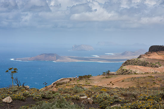
En el mirador de El Bosquecillo podremos conjugar nuevamente los diferentes paisajes con la opción de contemplar Famara e incluso un pequeño pero significativo punto de la isla de La Graciosa (isla del Archipiélago Chinijo, al norte de Lanzarote), Montaña Amarilla. No se confunda el lector con la terminología y piense encontrar miles de hectáreas de pinos, laureles de la India o palmeras canarias. Desgraciadamente, El Bosquecillo lo componen algunos arbolillos, un centenar aproximadamente, muchos quemados, otros mal cuidados, y sin embargo resultan apañadillos. La socarronería conejera ha rebautizado al espacio como El Peladillo, echando en falta una decidida plantación de variada arboleda. Por lo demás es éste un buen lugar para la práctica deportiva, los juegos de mesa, la contemplación, la lectura y, los más animados, una buena parranda timple y guitarra mediantes.

Nota: Ocio Lanzarote agradece el trabajo fotográfico de Dani Stein que ilustra esta entrada informativa. Sus fotos.

Ver mapa más grande

You might also like

Explore similar topics

Similar Articles:

Femés-Papagayo

To the heart of the Natural Monument of Los Ajaches. This is a path that will allow us to cross one of the natural attractions of southern Lanzarote. Can not be compared with its neighbors and the Timanfaya Geria, but the route, visually monotonous in almost all the way, trapped by his strange charm. Although not difficult nor extremely hard the road, no recommendations addressed to children under 14 years.

Teguise – Famara

At times we will only have eyes for the <strong>immense Famara cliff</strong>. But our eyes, inevitably get caught by the beauty of the islands of <strong>La Graciosa</strong>, <strong>Alegranza</strong> and <strong>Montaña Clara</strong>. Back on Lanzarote, the <strong>extension of the natural volcanic sand called <em>jable</em></strong> seems endless from above and it gets less dry and yellowish as our gaze moves towards Mozaga.

Femés-Playa Quemada

In the direction of Playa Quemada, one of the most spectacular beach on the island. From the first moment we perceive the immense valley of Femés to cross during the day. In general, the paths to walk are tight, corresponding to very traditional herds of goats in the area. Accordingly, in a first stage, we must walk carefully along the banks of the trail and very zigzaceantes soil slopes, uneven and poor care.

Caleta del Sebo-Montaña Amarilla

ADDRESSING: Departure by boat from Órzola (north of Lanzarote) to Caleta del Sebo (La Graciosa). On foot or by bike (the bike we can take from Lanzarote or rent it...