La Asomada-La Geria

La Asomada-La Geria

ADDRESSING: Leave a car at Bodegas La Geria and one in the conurbation of La Asomada, in the direction of Gering. DISTANCE: 6 miles. DIFFICULTY: Low. DURATION: Two hours. PLEASE NOTE: Wear appropriate clothing and shoes. Water. Some chocolate and pastries. Hat and sunscreen. Do not forget the phone.

This is a path suitable for the whole family. About two hours long, the journey, except in a small dimensions, it is easy to tackle. Highlight the spectacular views of the Timanfaya Geria and in much of the trail coexist in a common framework. We can start the kick in the conurbation of the Asomada from the road linking this town with the countryside of La Geria. Heading south we have several options to get through the thousands of vines, c Oquete shelter from the winds, amid the volcanic rofe very typical of the area. Very soon we will find the road that connects with The Geria Masdache, perpendicular to the downward path of the Asomada. Carefully cross the road and stumbled on a heap of black with a white masthead feature in its slope.

Espectaculares vistas de La Geria, Lanzarote

Go around the mountain to the southwest. As in almost all the way, these first pictures are a delight from the standpoint of contemplation. The grooves, which limits the volcanic rock and vine plantations form a clearly differentiating active in the landscape of Lanzarote. Rofe along with strong black and red edges that can be made out of Timanfaya, the trail invites you to stop at times and lose the view from north to south. While walking through this space easily or, it is pertinent to emphasize that we are in a protected natural area and we should kick it with great care through the paths present in almost the whole way.

Paisajes de La Geria y Timanfaya se funden en uno, Lanzarote

After half an hour away, since we have lined the first mountain, we enter the most beautiful stage of the path, still heading south. The union of the beauties of the Gering and Timanfaya is one of those things you need to experience live. So different and yet, its rhythms become one. The vine and the rofe of vineyards are coupled with this picture volcanic Timanfaya back. A spree of assaults colors and fills the view. The sky blue frames the mont yeors ocher, black and red of the National Park. From this crucible volcano, although it may seem paradoxical, sprouts varied vegetation, such as tabobos, the gorse and hundreds of figs. It is advisable at this stage of the journey walking around the area of rofe and avoid volcanic area.

When we stumble across the road the second highest mountain, as in the previous one, bordered on the southwest and southeast. In its middle section will find a small building surrounded by trees. This is a good time for rest and refreshment, while relaxing with spectacular views. A short descent brings us to another small mountain shaped caldera. His approach is simple and worth it, because inside this mound there are u nas few plantations of vines (see photo at right).

Caldera volcánica con plantación de viñas en La Geria, Lanzarote

With the same strategy as in the previous levels will surround a third mountain. Is easily identified because they ran up a fence that marks a good number of hectares to the south. We walk to the left of this protection, being careful not to erode the area and avoiding excessive weaving through the mountain of black rofe. A quarter of an hour does this road along the fence, ending again in the vineyards of Bodegas La Geria with e Timanfaya Spalde at his side.

Once we overcome this point, walk southwest to southeast reaching into another quarter of an hour Bodegas La Geria, with tasting area their own wines or suggestive corner of tapas and wines The Chupadero . These two options apply to continue the journey in the midst of nature after the kick. A quarter of an hour away by car diversify the dining options in Femés or southbound Gulf, and Monumento al Campesino the north by the road The Geriatrics Masdache-San Bartolomé.


Ver mapa más grande

You might also like

Explore similar topics

La Asomada-La Geria

CÓMO ABORDARLO: Dejar un coche en Bodegas La Geria y otro en la conurbación de La Asomada, en dirección a La Geria. DISTANCIA: 6 kilómetros aproximadamente. DIFICULTAD: Baja. DURACIÓN: Dos horas y media. A TENER EN CUENTA: Llevar ropa y calzado adecuado. Agua. Alguna chocolatina y bollería. Gorra y crema solar. No nos olvidemos del móvil. PARA DESPUÉS DEL PATEO: Tapas y vinos en Bodegas La Geria, El Chupadero (La Geria); almuerzo en Femés, El Golfo o Monumento al Campesino (a unos 15 minutos de la conclusión del sendero).

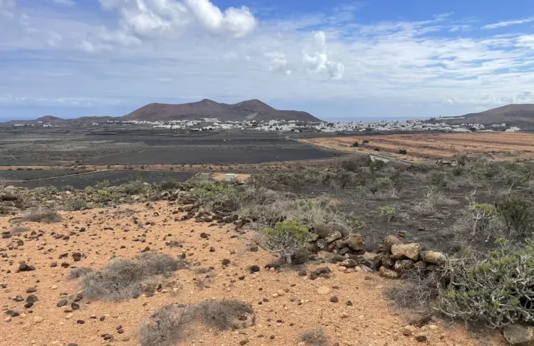
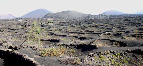
Este es un sendero apto para toda la familia. De unas dos horas y media de duración, el trayecto, salvo en unas pequeñas cotas, resulta muy sencillo de abordar. Destacan las espectaculares panorámicas de La Geria y Timanfaya que en buena parte del sendero conviven en un marco común. El pateo lo podemos iniciar en la conurbación de La Asomada, desde la carretera que une este pueblo con el espacio natural de La Geria. En dirección sur tenemos diversas opciones para atravesar las miles de parras, coquetamente guarecidas de los vientos, en medio del rofe volcánico muy típico de la zona. Muy pronto encontraremos la carretera que une Masdache con La Geria, perpendicular a la vía descendente de La Asomada. Con cuidado cruzaremos el asfalto y tropezaremos con una montañita de color negro con una característica mancheta blanca en su loma.

Espectaculares vistas de La Geria, Lanzarote

Rodearemos la montaña en dirección suroeste. Como en casi todo el camino, estas primeras estampas constituyen un deleite desde el punto de vista contemplativo. Los surcos, la piedra volcánica que limita las plantaciones y la viña conforman un activo claramente diferenciador en el paisaje lanzaroteño. Junto al fuerte rofe negro y los bordes rojizos que se adivinan de Timanfaya, el sendero invita a parar por momentos y perder la vista de norte a sur. Si bien se camina con facilidad por este espacio, resulta pertinente insistir en que nos hallamos en un espacio natural protegido y que debemos patear con sumo cuidado a través de las veredas presentes en casi todo el trayecto.

Paisajes de La Geria y Timanfaya se funden en uno, Lanzarote

A la media hora de camino, toda vez que hemos bordeado esta primera montaña, nos adentraremos en la etapa más bonita del sendero, siempre en dirección sur. La unión de las bellezas de La Geria y Timanfaya es de esas cosas que hay que vivir en directo. Tan diferentes y, sin embargo, sus ritmos se hacen uno. La parra y el rofe de los viñedos se acoplan con esta estampa volcánica de la espalda de Timanfaya. Una juerga de colores asalta e inunda la vista. El azul celeste del cielo enmarca a las montañas ocres, negras y rojizas del Parque Nacional. De este crisol volcánico, aunque pueda resultar paradójico, brota variada vegetación, como los tabobos, las aulagas y cientos de higueras. Se aconseja en esta fase del trayecto caminar por la zona de rofe y evitar el espacio volcánico.

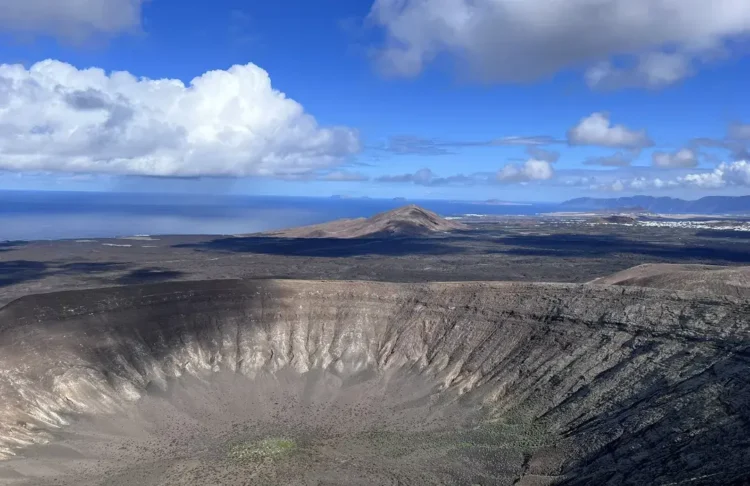
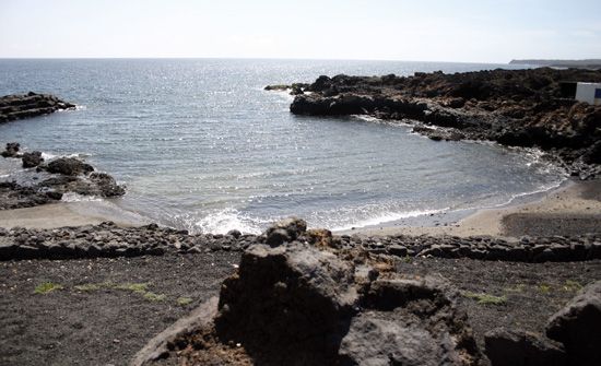
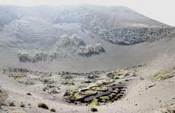
A la hora de camino tropezaremos con la segunda montaña que, como en la anterior, bordearemos en dirección suroeste-sureste. En su parte intermedia encontraremos una pequeña construcción arbolada. Este es un buen momento para el descanso y el avituallamiento, a la vez que relajadamente contemplamos las espectaculares vistas. Un pequeño descenso nos llevará a otra pequeña montaña en forma de caldera. Es sencilla su aproximación y vale la pena, porque en el interior de esta montañita también hay unas pocas plantaciones de viñas (ver foto a la derecha).

Caldera volcánica con plantación de viñas en La Geria, Lanzarote

Con la misma estrategia que en las cotas anteriores rodearemos una tercera montaña. Se identifica con facilidad porque tropezaremos con una valla que delimita un buen número de hectáreas en dirección sur. Debemos caminar por la izquierda de esta protección, con cuidado para no erosionar excesivamente la zona y evitando zigzaguear por la montaña de rofe negro. Un cuarto de hora aproximadamente lleva este camino junto a la valla, terminando, nuevamente, en los viñedos de Bodegas La Geria con la espalda de Timanfaya a su vera.

Una vez que superamos este punto, caminaremos en dirección suroeste-sureste alcanzando en otro cuarto de hora aproximado Bodegas La Geria, con su zona de degustación de sus propios caldos o el sugerente rincón de tapas y vinos de El Chupadero. Estas dos opciones son válidas para continuar con la jornada en medio de la naturaleza después del pateo. A un cuarto de hora en coche aproximadamente diversificamos las posibilidades gastronómicas en Femés o El Golfo en dirección sur, y en el Monumento al Campesino al norte, por la carretera La Geria-Masdache-San Bartolomé.

Ver mapa más grande

You might also like

Explore similar topics

Similar Articles:

Femés-Papagayo

To the heart of the Natural Monument of Los Ajaches. This is a path that will allow us to cross one of the natural attractions of southern Lanzarote. Can not be compared with its neighbors and the Timanfaya Geria, but the route, visually monotonous in almost all the way, trapped by his strange charm. Although not difficult nor extremely hard the road, no recommendations addressed to children under 14 years.

Teguise – Famara

At times we will only have eyes for the <strong>immense Famara cliff</strong>. But our eyes, inevitably get caught by the beauty of the islands of <strong>La Graciosa</strong>, <strong>Alegranza</strong> and <strong>Montaña Clara</strong>. Back on Lanzarote, the <strong>extension of the natural volcanic sand called <em>jable</em></strong> seems endless from above and it gets less dry and yellowish as our gaze moves towards Mozaga.

Haría – El Bosquecillo

The valley of the thousand palm trees of Haría is one of the most spectacular pieces of the varied landscape of Lanzarote.

Femés-Playa Quemada

In the direction of Playa Quemada, one of the most spectacular beach on the island. From the first moment we perceive the immense valley of Femés to cross during the day. In general, the paths to walk are tight, corresponding to very traditional herds of goats in the area. Accordingly, in a first stage, we must walk carefully along the banks of the trail and very zigzaceantes soil slopes, uneven and poor care.