Femés-Papagayo

Femés-Papagayo

ADDRESSING: Leaving a vehicle on the beach of conger, campground of Papagayo, and another at the entrance or exit Femés South, next to the Mirador of the people. DISTANCE: 9 miles. DIFFICULTY: Medium. DURATION: Four hours. PLEASE NOTE: Wear appropriate clothing and shoes. Water (in this case, abundant water). Some chocolate and pastries. Hat and sunscreen. Do not forget the phone.

To the heart of the Natural Monument of Los Ajaches. This is a path that will allow us to cross one of the natural attractions of southern Lanzarote. Can not be compared with its neighbors and the Timanfaya Geria, but the route, visually monotonous in almost all the way, trapped by his strange charm. Although not difficult nor extremely hard the road, no recommendations addressed to children under 14 years. The network of trails in Los Ajaches is one of the few well-marked Lan zarote. At the exit south of Femés find the path that will put us in the beginning of the road.

senderofemes-papagayo

We climb a small dimension and right at the foot of the valley overlooking the southeastern coast of the island, find maps with different paths on poles with a colored markers (Femés-Playa Quemada, Femés-Pico Redondo, and obviously our way: Femés-Playa Blanca, see top photo on the bottom right).

vistasplayablanca

Located on route starts south on a narrow path of traditional use of goats. Check that you have to be very aware of the firm and that his is, against the spectacular views are from the start, stop, watch and follow the path focused on narrow margins of the trail.

corralcabras-losajaches

The dry environment of the area does not, as in other scenarios island, the proliferation of cactus and small trees known as Boobies dotting the dry stamp of Los Ajaches. After half an hour away, once surrounded the hill first dimension in the cutthroat Morro del Perro, find an excellent position to contemplate calmly Postal Playa Blanca Isla de Lobos and Fuerteventura Corralejo dunes in the background, the Salinas Janubio and peoples Maciot and The Breñas.

In this area, around the time of route, find another road signage, a new post with two markers, red and orange, which details the route to continue. At our feet get a goat pen (see photo at right). We must be guided by the red path, which will put us in a wider track and secure the goat for which we have traveled so far.

monumentolosajaches

At this point we enter the east side of Los Ajaches in search of the Peña de los dises. The magnetism of this nature is seen in his dry, yet colorful. The reds, oranges, browns and blacks come together and interspersed with splashes of green cactus, and the everlasting tabaibas Boobies .

This stage of the trail becomes monotonous. The village, in continuous zig zag, seem never ending and for over an hour and a half, you come to doubt, at times, the appearance of Papagayo. In this way we can divert to the coast, if we identify the point of return to the road. It will contemplate some lovely coves and cliffs. Secluded and peaceful bathroom spaces that inhabit the southeastern part of Lanzarote (see photo at right).

acantiladopapagayo

We approach the final stretch of trail. Finally, on the horizon, one guesses the figure of Papagayo. The stage is transformed into desert full of gorse. There is a special harmony between these beaches, Isla de Lobos and the dunes of Corralejo. They look like a unit. We arrived at the beach Conger, camping so crowded during the summer just be alone. In the end of September (Tuesday, 30 September) at 14:30 hours, two people are the owners of the beach. No blow or na breath of wind. The spectacular waters are waiting for him to break the stillness. After four hours of immersion in them is like a second baptism.

playacongrio-papagayo


Ver mapa más grande

You might also like

Explore similar topics

Femés-Papagayo

CÓMO ABORDARLO: Dejar un vehículo en la playa del Congrio, el camping de Papagayo, y otro en la entrada o salida del sur de Femés, al lado del Mirador de este pueblo. DISTANCIA: 14 kilómetros aproximadamente. DIFICULTAD: Media. DURACIÓN: Cuatro horas. A TENER EN CUENTA: Llevar ropa y calzado adecuado. Agua (en este caso, abundante agua). Alguna chocolatina y bollería. Gorra y crema solar. No nos olvidemos del móvil.

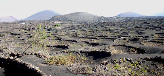
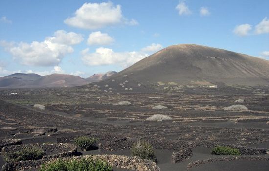
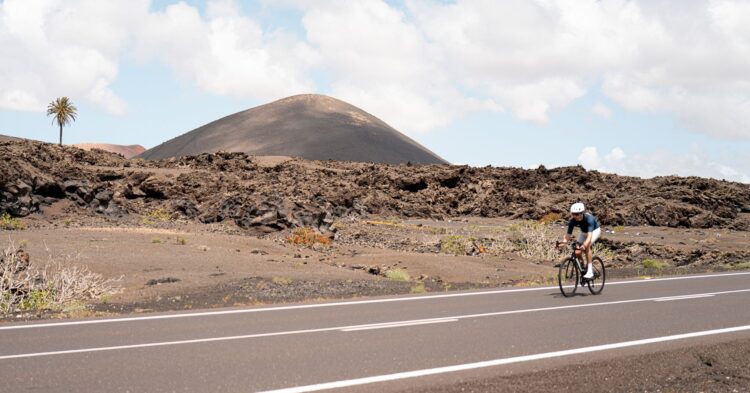
Hacia el corazón del Monumento Natural de Los Ajaches. Éste es un sendero que nos permitirá atravesar uno de los atractivos naturales del sur de Lanzarote. No puede compararse con sus vecinos Timanfaya y La Geria, pero la ruta, visualmente monótona en casi todo su recorrido, atrapa por su extraño encanto. Aunque no resulta difícil ni extremadamente duro el camino, no recomendamos abordarlo con niños menores de 14 años. La red de senderos de Los Ajaches es una de las pocas bien señalizadas de Lanzarote. En la salida al sur de Femés hallaremos la vereda que nos situará en el inicio del camino.

senderofemes-papagayo

Deberemos ascender una pequeña cota y justo a los pies del valle que mira a la costa sureste de la isla, encontraremos unos mapas con diferentes veredas en unos postes con unos marcadores de colores (Femés-Playa Quemada, Femés-Pico Redondo y, obviamente, nuestro camino: Femés-Playa Blanca, ver foto superior en el margen inferior derecho).

vistasplayablanca

Localizado el itinerario partiremos en dirección sur por un estrecho camino de uso tradicional de cabras. Comprobarán que hay que estar muy pendiente del firme y que lo suyo es, frente a las espectaculares vistas que encuentran desde el inicio, detenerse, contemplar y seguir la ruta concentrado en los márgenes estrechos del sendero.

corralcabras-losajaches

El ambiente seco de la zona no impide, como en otros escenarios insulares, la proliferación de tuneras y los pequeños arbolitos conocidos como bobos que salpican la estampa seca de Los Ajaches. A la media hora de camino, una vez rodeada la primera cota montañosa, en la degollada Morro del Perro, encontraremos una excelente posición para contemplar tranquilamente la postal de Playa Blanca con Isla de Lobos y las dunas de Corralejo de Fuerteventura al fondo, las Salinas de Janubio y los pueblos de Maciot y Las Breñas.

Por esta zona, alrededor de la hora de ruta, encontraremos otra señalización del camino, un nuevo poste con dos marcadores, rojo y naranja, que detalla el itinerario a continuar. A nuestros pies aparece un corral de cabras (ver foto a la derecha). Debemos guiarnos por el sendero rojo, que nos situará en un camino más ancho y seguro que el de cabras por el que hemos transitado hasta este momento.

monumentolosajaches

En este punto nos adentraremos en la cara este de Los Ajaches, en busca de la Peña de los Dises. El magnetismo de este espacio natural se percibe en su ambiente seco y sin embargo colorido. Los tonos rojizos, naranjas, ocres y negros se funden e intercalan con las salpicaduras verdes de las tuneras, las tabaibas y los sempiternos bobos.

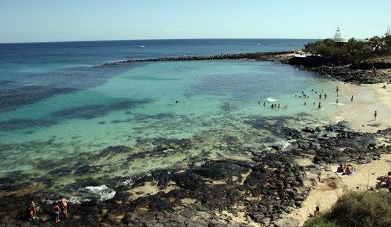
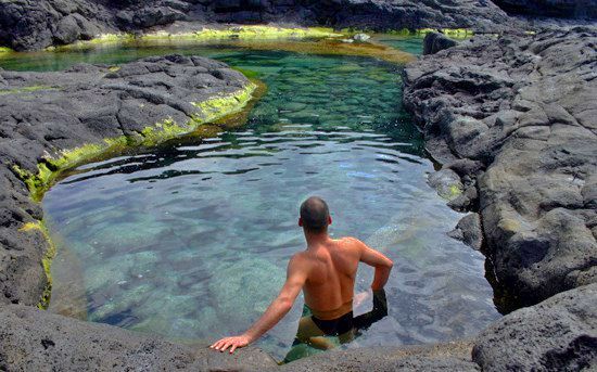
Esta etapa del sendero se torna más monótona. La vereda, en continuo zig zag, parece que nunca termina y durante más de hora y media se llega a dudar, por momentos, de la aparición de Papagayo. En este trayecto podemos desviarnos hacia la costa, siempre que identifiquemos el punto de retorno al camino. En ella contemplaremos unas encantadoras calas y acantilados. Recónditos y pacíficos espacios de baño que pueblan la zona sureste de Lanzarote (ver foto a la derecha).

acantiladopapagayo

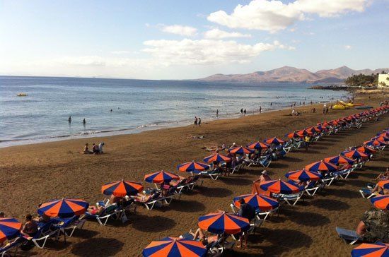
Afrontamos la recta final del sendero. Por fin, en el horizonte, se adivina la figura de Papagayo. El escenario se transforma en desértico plagado de aulagas. Hay una especial consonancia entre estas playas, Isla de Lobos y las dunas de Corralejo. Parecen una unidad. Llegamos a la playa del Congrio, el camping tan abarrotado durante el verano acaba de quedar solitario. En este finales de septiembre (martes, 30 de septiembre), a las 14:30 horas, dos personas son las dueñas de la playa. No sopla una brizna de viento. Sus espectaculares aguas están a la espera de que rompamos su quietud. Después de cuatro horas, la inmersión en ellas se asemeja a un segundo bautismo.

playacongrio-papagayo

Ver mapa más grande

You might also like

Explore similar topics

Similar Articles:

Teguise – Famara

At times we will only have eyes for the <strong>immense Famara cliff</strong>. But our eyes, inevitably get caught by the beauty of the islands of <strong>La Graciosa</strong>, <strong>Alegranza</strong> and <strong>Montaña Clara</strong>. Back on Lanzarote, the <strong>extension of the natural volcanic sand called <em>jable</em></strong> seems endless from above and it gets less dry and yellowish as our gaze moves towards Mozaga.

Haría – El Bosquecillo

The valley of the thousand palm trees of Haría is one of the most spectacular pieces of the varied landscape of Lanzarote.

Femés-Playa Quemada

In the direction of Playa Quemada, one of the most spectacular beach on the island. From the first moment we perceive the immense valley of Femés to cross during the day. In general, the paths to walk are tight, corresponding to very traditional herds of goats in the area. Accordingly, in a first stage, we must walk carefully along the banks of the trail and very zigzaceantes soil slopes, uneven and poor care.

Caleta del Sebo-Montaña Amarilla

ADDRESSING: Departure by boat from Órzola (north of Lanzarote) to Caleta del Sebo (La Graciosa). On foot or by bike (the bike we can take from Lanzarote or rent it...