Los Charcones-Las Salinas de Janubio
CÓMO ABORDARLO: Dejar un vehículo en la playa de Janubio y otro en el hotel abandonado de Los Charcones, a unos tres kilómetros al norte de Pechiguera, Playa Blanca. DISTANCIA: 10 kilómetros. DIFICULTAD: Media-Alta. DURACIÓN: Tres y media o cuatro horas. A TENER EN CUENTA: Llevar ropa y calzado adecuado. Agua. Alguna chocolatina y bollería. Gorra y crema solar. No nos olvidemos del móvil. No confiarnos con la fuerza del mar característico de esta zona. Extremar la precaución si acuden niños o jóvenes. PARA DESPUÉS DEL PATEO: Chapuzón en las piscinas naturales de Los Charcones. Visitar los Hervideros, Charco de los Clicos y El Golfo. Almorzar en El Golfo, Femés o Playa Blanca (a 5, 10 y 15 minutos en coche respectivamente).
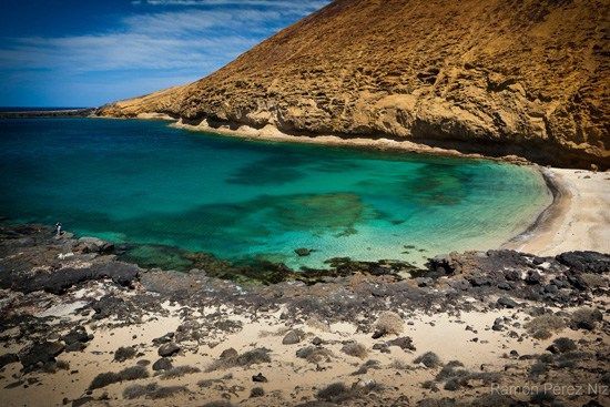
Los Charcones se localizan a unos tres kilómetros al noroeste del Faro de Pechiguera de Playa Blanca. El inicio lo identificaremos con facilidad al contemplar dos moles de cemento junto a la costa que, hace unos 30 años, pretendía erigirse en una instalación hotelera. Hoy, todavía en pie, abandonado, ofrece un aspecto lamentable a tres pasos de una de las porciones de costa más atrayentes de Lanzarote. El océano Atlántico castiga con virulencia la franja oeste de la isla que unido a las condiciones geológicas de la zona han creado múltiples piscinas naturales. No se aconseja el baño en la mayoría de ellas por la cercanía de la mar, pero en algunas pocas y en condiciones de seguridad el chapuzón asocado de los fuertes vientos imperantes en estas calas ofrecen una jornada diferente, auténtica.
Las mejores piscinas, en nuestra opinión, se encuentran a unos pocos metros al norte del hotel abandonado. Su acceso, de animarse a probar sus aguas después del sendero, es bastante dificultoso, en un terreno accidentado de lava en descenso, pero superable si tenemos unas mínimas condiciones físicas y prestamos atención en toda la bajada.
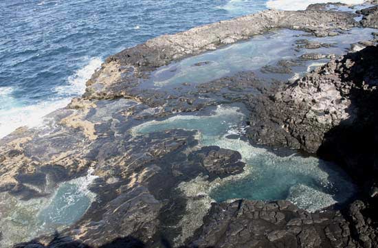
La imagen superior es la estampa que, en dirección norte, se repetirá en la primera etapa de esta caminata. El mar azul, la lava solidificada en tonos negro y un suave rojizo y el agua de los charcones azul-verdosa en su profundidad. Las garzas y las gaviotas acompañan el crujir de las olas al acecho de los alimentos del mar que, en cualquier momento, puedan exponerse a sus pacientes picos. El camino resulta incómodo por la inundación de piedra volcánica que parece proteger la costa. Por ello es conveniente, como en cualquier pateo, equiparse con un apropiado calzado para rutas de este tipo.
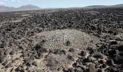
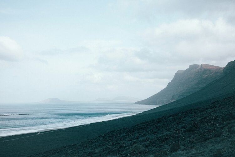
La continuación del pateo hacia el norte es una clara muestra de la dejadez institucional lanzaroteña en cuanto al cuidado y mimos que merecen estas rutas. A la falta de información presente en todos los senderos, a excepción del Femés-Playa Quemada, el camino al norte hacia Salinas de Janubio parece un descampado desolado y desorganizado, más propio de lugares desahuciados que de espacios que esconden maravillas como con las que muy pronto volveremos a contemplar. Entre el desahucio se salva levantar la vista al este, donde aparece majestuosamente el Monumento Natural de Los Ajaches, la extraña vegetación que nace de estos páramos, los esqueletos de las raíces de unos árboles que nunca pudieron levantar el vuelo por culpa de los fuertes vientos y las múltiples huellas de ciudadanos ejemplares que patearon por la zona (botellas de cervezas, bolsas, esclavas, zapatos…).
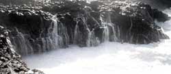
De vuelta a la costa, pasada ya la hora de pateo, se suceden los saltos del agua a unos 20-30 metros de donde rompen las olas. Observar cómo estalla la espuma y se baña la orografía aledaña resulta un espectáculo. Otro fenómeno muy curioso que se da en la zona es comprobar cómo el agua se introduce en cuevas subterráneas y emerge a través de un aliviadero metros más arriba (ver foto inferior). La imagen se suma al fuerte sonido que acompaña la evacuación del agua sobrante en la cueva. Es éste un buen punto para reponer fuerzas y relajarse con el embriagador sonido y su estampa resultante.
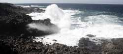
Retomando el camino hacia el norte, siempre hacia el norte en esta propuesta de sendero, seguiremos contemplando esos baños que refrescan la lava solidificada por la tremenda potencia de las olas. Hay que vislumbrar el punto estratégico indicado para ver estos rompientes en condiciones de seguridad. Olas de cinco o seis metros que rompen en un pequeño descenso de la franja inferior de roca y que emprenden una alocada carrera hasta estamparse con violencia en un muro volcánico de unos diez metros de altura. La imagen inferior habla por sí sola de esta especie de fuegos artificiales acuáticos tan habitual en la zona.

Después de la tempestad siempre viene la calma. La ola deja un reguero de agua que forma esta imagen tan curiosa y relajante (ver foto a la derecha). Con series de olas buenas podremos disfrutar de cuantos fuegos artificiales queramos. Eso sí, insistimos en que antes de verlos debemos elegir un buen sitio, del que estemos seguros que el agua no pasará para evitar males mayores.
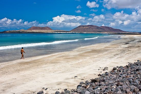
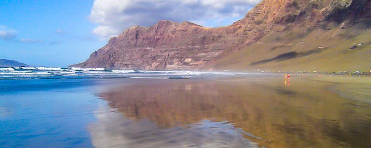
Alrededor de las dos horas y media de pateo en dirección norte abordamos la recta final de este sendero. Pasaremos junto a la planta de agua de Inalsa sur de Janubio, estamos, pues, a unos pocos kilómetros de la playa negra y Las Salinas de Janubio. En esta zona parece que el mar se tranquiliza un poco y el camino es mucho más ágil. Hoy (domingo, 2 de diciembre de 2007), la siempre inquieta playa de Janubio mantiene una relativa paz, se observa movimiento de mucho turista y a la espalda de la playa aparecen pacíficas las salinas de sal de Janubio. Tres horas y media de caminata. Stop. Ahí está nuestro coche. ¿Vamos a las piscinas naturales, al hotel abandonado, y nos damos un baño o tiramos a El Golfo y arrasamos con un mero para siete? Hay sed y mucha hambre. 10 minutos después probamos la respuesta: seis cervezas, una botella de agua sin gas, ensalada de la casa, papas arrugadas con mojo rojo y verde, calamares a la romana, lapas y un bocinegro para tres (el mero para siete era demasiado…demasiado caro). Sin duda, un domingo diferente.